
Space Seed Holdings Releases “satellite-landuse-toolkit,” an Open-Source Tool for Land-Use Analysis with Satellite Data
Space Seed Holdings Inc. (Headquarters: Minato-ku, Tokyo; Representative Director and CEO: Kengo Suzuki; “SSHD”) released “satellite-landuse-toolkit,” a tool that reproducibly aggregates and analyzes regional land cover, tree-cover loss, surface-water change and more from public satellite data, as open source (MIT License) on GitHub on September 13, 2026, and obtained a DOI (Digital Object Identifier) for it on the research data repository Zenodo.
The tool was developed as part of SSHD’s core business, research and development related to SpaceAgent*, a platform for conducting research autonomously both in space and on the ground. It was designed for use in SSHD’s own regional businesses and also in the next-generation education business and corporate and municipal R&D of Spacenome Inc. (Headquarters: Shinjuku-ku, Tokyo; Representative Director: Daigo Fujita; “Spacenome”), in which SSHD has invested and where Suzuki serves as Director of SPACE LAB.
*SpaceAgent is a collective term for a research platform in which AI, such as large language models (LLMs), links observation, judgment and operation to carry out cell culture, various scientific experiments and data analysis autonomously. SSHD positions R&D related to this platform as its core business, and in June 2026 announced that it had filed two patent applications on apparatus and control methods supporting autonomous experiments in the space environment, jointly with Regenesome Inc., IDDK Co., Ltd. and Spacenome.
Background: satellite data are accessible, but hard to interpret correctly
Land-cover maps at 10 m resolution, annual tree-cover loss data spanning more than 20 years, about 40 years of surface-water history from 1984 to 2024, and optical satellite images every five days are all freely available. The materials for understanding regional land use exist. In practice, however, using them tends to require cloud analysis accounts, API keys and GIS expertise, and it is not easy for third parties to reproduce the same results. For company staff and students who want to study a region, not only researchers, the first step often stops there.
Harder than the aggregation itself is interpretation. Tree-cover loss data do not subtract regrowth, so “remaining forest” cannot be calculated from them; the accuracy of a land-cover map is a global average, not the accuracy for a particular region; and comparing satellite images from two dates is affected by clouds, seasons and co-registration. Expert reviews always point out such over-reading, yet tools have offered almost no mechanisms to prevent it.
Overview of the tool
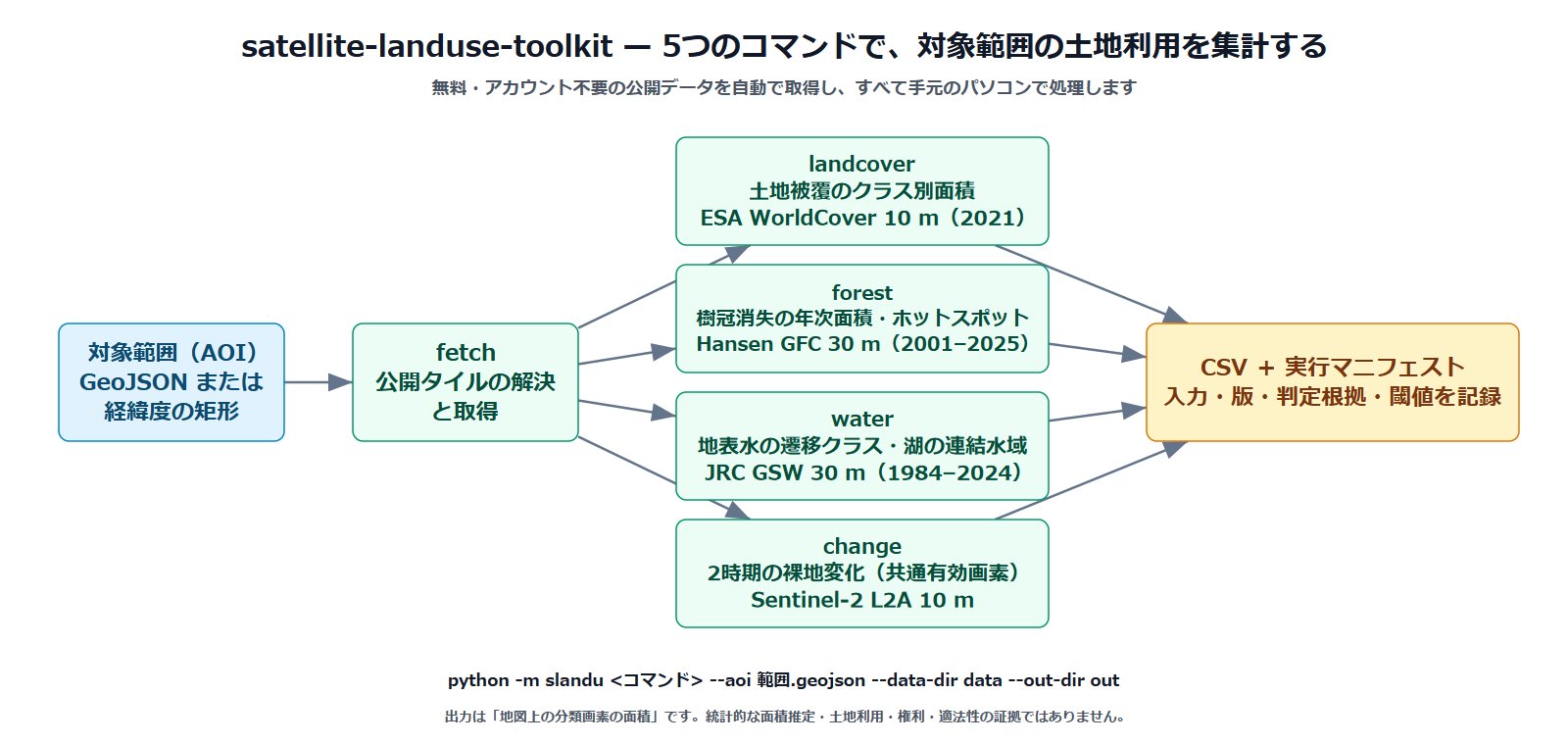
Given only an area of interest (GeoJSON or a latitude-longitude rectangle), satellite-landuse-toolkit resolves and downloads the necessary public tiles and aggregates them with five commands. It does not use cloud platforms such as Earth Engine or API keys; everything runs on a local computer.

- fetch: resolves and downloads the public tiles covering the area; searches Sentinel-2 scenes
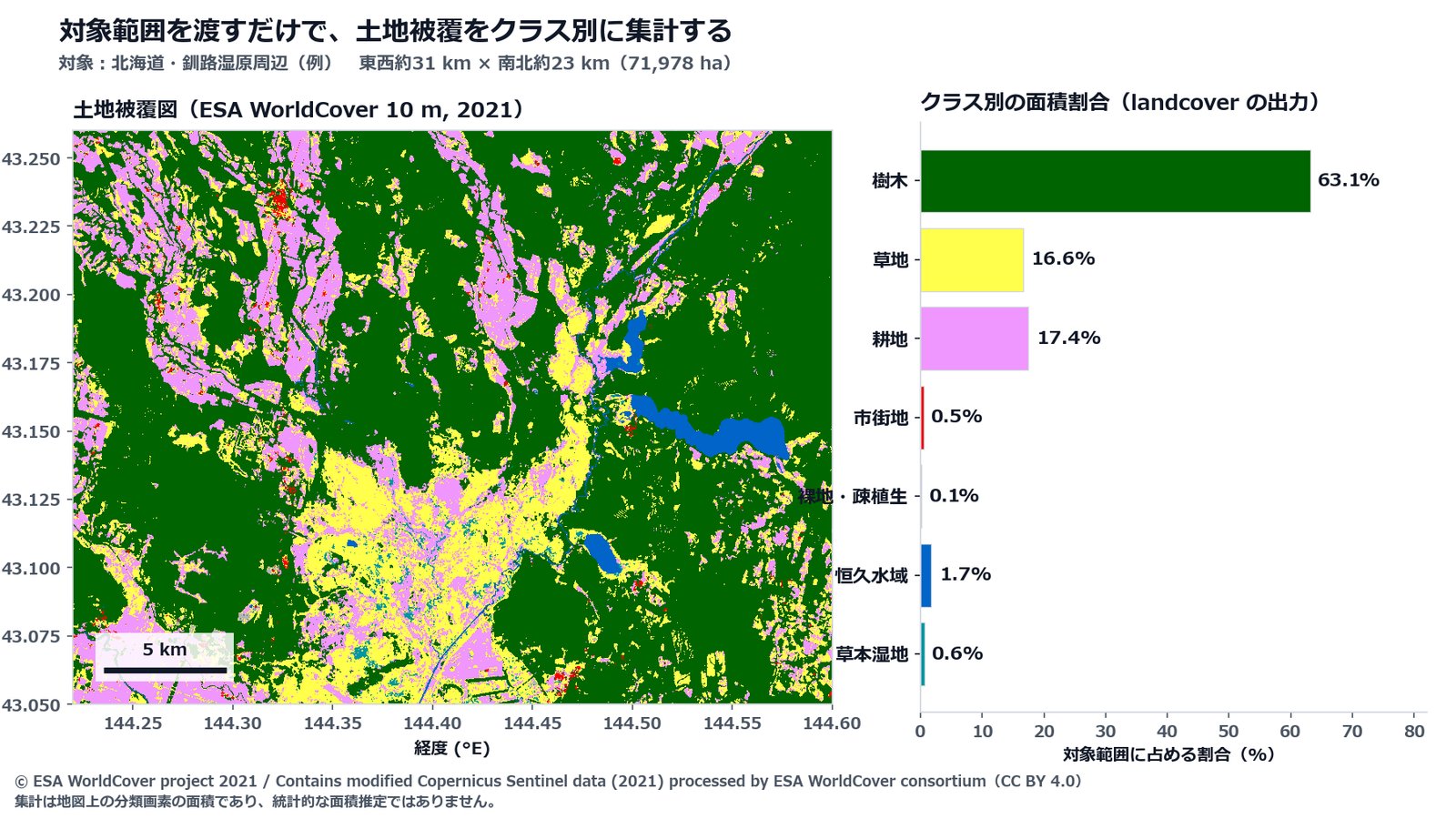
- landcover (ESA WorldCover 10 m, 2021): area by land-cover class
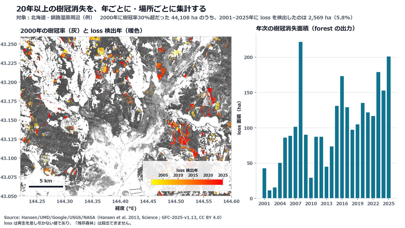
- forest (Hansen Global Forest Change 30 m, 2001–2025): annual tree-cover loss area, tile coverage, threshold sensitivity, and hotspots at about 1 km
- water (JRC Global Surface Water 30 m, 1984–2024): area by water transition class; the connected water body of a specified lake
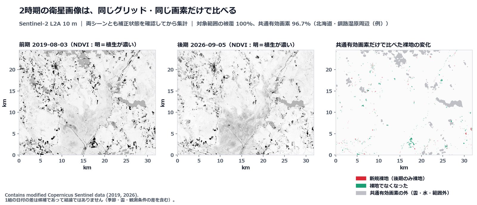
- change (Sentinel-2 L2A 10 m): two-date bare-ground change on a common grid using only commonly valid pixels, with a run manifest
Design features: safeguards against over-reading built into the tool
- Stops when it cannot confirm: if the reflectance-correction status of Sentinel-2 cannot be determined from metadata, the tool stops and asks the user rather than guessing and continuing. It also cross-checks using the reflectance of water pixels.
- Compares only the same pixels: for two-date comparison, both scenes are reprojected to a single reference grid, and only pixels that are free of cloud and water on both dates (commonly valid pixels) are counted. The share of valid pixels is reported.
- Does not hide gaps: all tiles covering the area are combined, and for forest, water (transitions) and change, the tool reports how much of the area the tiles or images actually covered.
- Leaves a record: input files, data versions, the basis for decisions and thresholds are written to a run manifest. Run records for the bundled example area (input-file hashes, commands and outputs) are also published so third parties can reproduce the same results.
- Comes with rules for wording: interpretive rules such as “distinguish mapped area from statistical area estimates” are bundled as a checklist in English and Japanese.
Use in education: studying “my town” with satellite data, including how to read the numbers
While keeping the rigor researchers need, the tool is designed so that it can be used as is in education.
- No cost, no registration: all data are free public data, with no account registration or API key required. It runs on ordinary computers at school or at home.
- Learners choose the area: by passing a single latitude-longitude rectangle, students can study the area around their town or school—land-cover composition, places where tree-cover loss has been detected since 2001, and changes in lakes and rivers—with the same procedure.
- Every step is visible: which files were obtained from where and which calculations were made remain in the commands and records, so the process, not only the result, can be used as teaching material.
- The safeguards become the lesson: bundled rules such as “mapped area is not a statistical area estimate” and “a two-date comparison yields candidates, not conclusions” are basic practices for handling data, connecting to data-literacy education using satellite data. SSHD has prepared a Japanese step-by-step guide that runs from data acquisition through two-date comparison using a domestic wetland area as an example, and is considering restructuring it for education.
Collaboration with Spacenome: toward education and corporate R&D
Leave a Nest Co., Ltd., Spacenome’s parent company, launched a space education project in 2008 as the first private company to use the paid utilization framework of the Japanese Experiment Module “Kibo” on the International Space Station. Building on this experience in space education, Spacenome now has two core businesses—the next-generation education business “NEST LAB.” and the space utilization research business “SPACE LAB.”—and is conducting R&D on SpaceAgent as one of SPACE LAB.’s activities. SSHD invested in Spacenome in March 2026, and Suzuki serves as Director of its SPACE LAB.
The tool was developed on the premise of considering its use in Spacenome’s activities in addition to SSHD’s regional businesses. Two directions are envisaged:
- Next-generation education: an inquiry-based program in which junior and senior high school students choose a region themselves, investigate the current state and changes of land use with satellite data, and reflect by comparing results with statistics and local information. SSHD will consider this with Spacenome as material for education that looks at Earth from space, and as material for learning the very process in which AI builds research tools and humans verify them.
- R&D with companies and local governments: SSHD will consider offering the tool as a common foundation for discussing the same procedure and the same numbers in situations where companies and municipalities need regional data, such as adding value to agricultural, forestry and fishery resources, tracking land-use change, and accountability for environmental considerations. Specific content and timing will be discussed by the two companies.
Development and verification process
The tool reached release after six rounds in which an AI agent implemented and tested it according to specifications, and an AI agent from a different lineage than the one used for development reviewed it independently. The reviews progressively found defects that do not surface in a single-region trial—missed merging of multiple tiles, errors in tile naming rules, co-registration of satellite images, handling of reflectance correction, and clipping of the area of interest—and each time fixes and regression tests (currently 26) were added. During review, the published run records were confirmed to match: the hashes of the six input files agreed, and the six output files were byte-for-byte identical in an independent environment.
This process puts into practice, using satellite data analysis as a ground-based subject, the way of conducting research that SSHD and Spacenome aim to realize with SpaceAgent, which they are developing to automate research: “AI does the hands-on work of research, another AI verifies it, and humans make the decisions.”
Release overview

- Name: satellite-landuse-toolkit (Python package name: slandu)
- Version: v1.0.0 (September 13, 2026)
- Repository: https://github.com/ss-hd-jp/satellite-landuse-toolkit
- DOI: 10.5281/zenodo.22730573 (all versions); 10.5281/zenodo.22730574 (v1.0.0)
- License: MIT (code). Each downloaded dataset is subject to its provider’s license.
- Requirements: Python 3.10 or later; rasterio, numpy, scipy, Pillow; the external command curl
- Bundled documents: data catalog (sources, licenses, citations, pitfalls), pre-delivery checklist, and run records (all in English and Japanese)
Comment
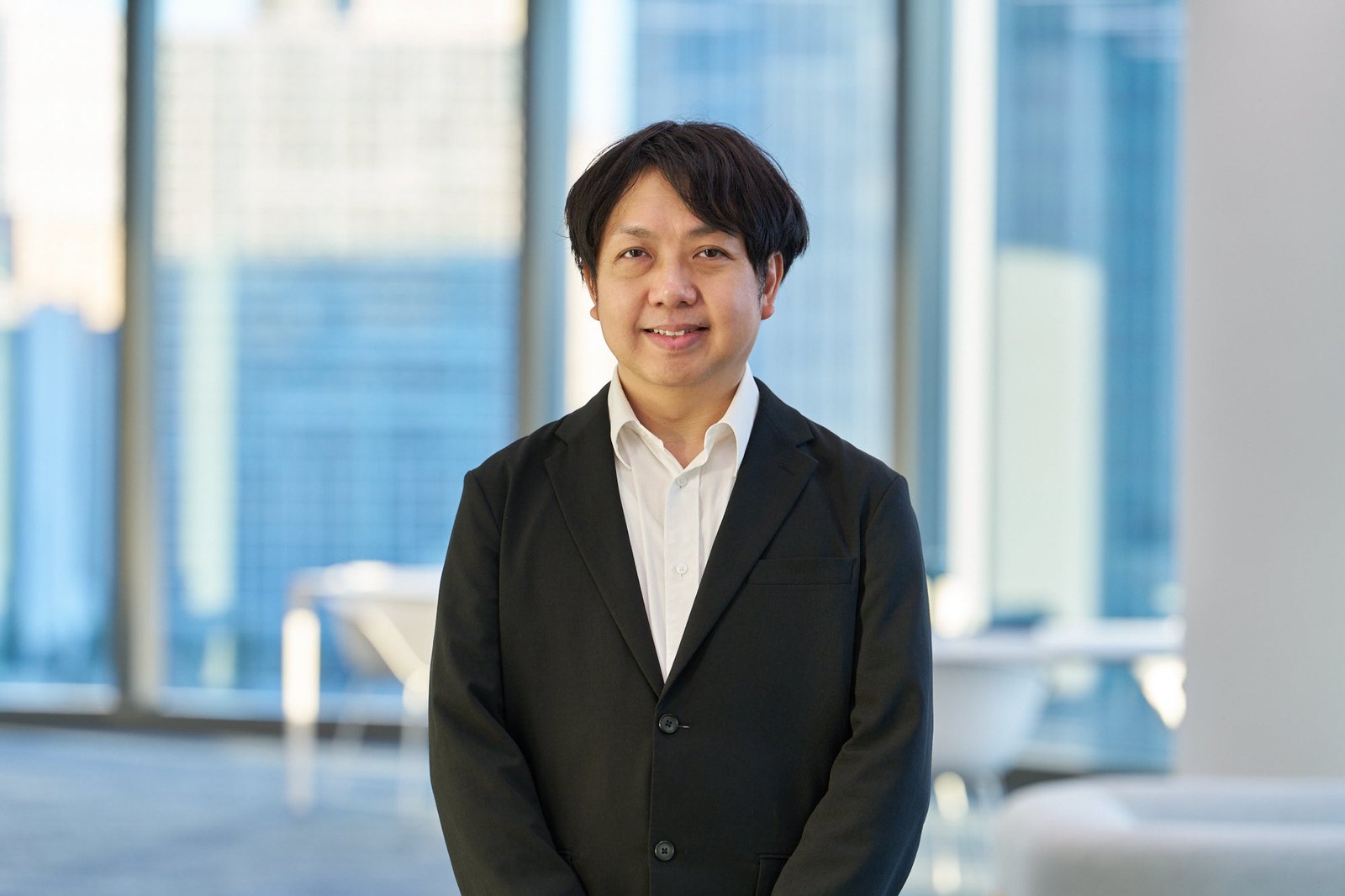
“We now live in an age when anyone can obtain satellite data. The hard part has been analyzing and interpreting it correctly. Looking at your own town from space, analyzing it, and thinking about what you can and cannot claim is an experience needed by junior and senior high school students and by people working in companies alike. I want to pursue that possibility at Spacenome, which has long worked on space education.”
—Kengo Suzuki, Representative Director and CEO, Space Seed Holdings Inc.; Director of SPACE LAB., Spacenome Inc.
Next steps
Starting from this tool, SSHD will pursue the following:
- Use in regional businesses in Japan and abroad: in regions working to add value to agricultural, forestry and fishery resources, use the tool to understand current land use and track change, as a foundation for discussing the same procedure and the same numbers with partners.
- Education programs: consider use in inquiry-based programs for junior and senior high school students with Spacenome, and restructure and publish the Japanese step-by-step guide based on a domestic wetland area for education.
- R&D with companies and local governments: consider, with Spacenome, use in joint research and training where companies and municipalities need regional data.
- Co-authorship with research institutions: consider joint presentations of land-use analyses using the tool with research institutions in the target regions.
- Applying it to research automation with AI: formalize the cycle established in this development—implementation by AI, independent review by an AI of a different lineage, and decisions by humans—as a verification procedure for the experiment-automation platform for space utilization research.
About Space Seed Holdings Inc.
Space Seed Holdings Inc. is a space-focused deep-tech venture builder whose mission is “Turning science fiction into nonfiction.” Through investment, research and venture creation—centered on operating the “Fermentation and Longevity Fund” program, which supports the social implementation of fermentation and longevity technologies—the company creates businesses that address societal challenges.
https://ss-hd.co.jp/